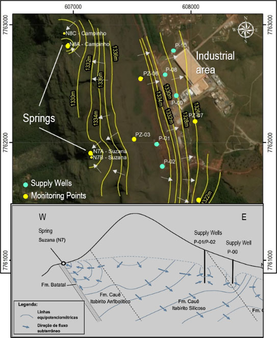
Our Brazilian partner WST (Water Services and Technologies) conducted a hydrogeological study to determine the potential impact on springs caused by industrial Water Wells.
CHALLENGE
To determine whether the decrease of flow rates in natural springs within an environmentally protected area was caused by lower-than-average multi-year precipitation or by Industrial Water wells.
SOLUTION
Installing dataloggers in 12 monitoring wells, 2 weirs, and 4 water supply wells and monitoring water level variations for a full hydrological year. Determine hydrogeological parameters through pumping tests. Pumping wells and piezometers were instrumented to record water level variations during the pumping tests. Four tests were performed, first by pumping the three abstraction wells separately for 72 hours, followed by pumping the three wells at the same time, during 132 hours.
RESULTS
The aquifer’s hydrodynamic parameters were determined, and the results showed that the combined drawdown cone resulting from pumping the three wells simultaneously was fairly restricted to the area where the wells are located, with no direct interference in the springs. The long term monitoring of all wells demonstrated that the groundwater divide did not change, indicating that the drying up of the springs was a consequence of the lower than usual precipitation rates that occurred in the previous three years. That was corroborated by the fact that as the precipitation rate during the monitored year was closer to average rates, groundwater levels went up and spring flow rates recovered.
Understanding the Causes of Variations of Flow Rates in Natural Springs
The Serra da Moeda natural conservation area was created by the State of Minas Gerais in Brazil, as it is the birthplace of many streams and rivers that form the main water supply source for the 6 million inhabitants of the metropolitan area of Belo Horizonte. Surrounding the conservation area there are many mining companies as well as some industrial plants.
During the three year period from 2014 to 2017, there was a significant decrease in the precipitation rate in the region, causing a significant reduction in the river flow rates and in groundwater levels. Two natural springs, which form some touristic water falls and are the only water source for local communities dried up during this period and the community saw an immediate correlation between this event and the operation of some water supply wells operated by a well known beverage company located nearby, on the other side of the mountain range. A thorough investigation was started by the company to understand the situation and ensure its business was operating in a sustainable way. After a two-year investigation it was demonstrated that the cause for the reduction in the flow rates was the lower-than-average precipitation rates and that the water supply wells did not affect the springs.
With the effects of climate change becoming more visible, this potential water conflict situation will occur more often, and it is important for large water users to establish long term monitoring programs in order to be ready to respond to claims raised by the community.

Results from 72hr Pumping Test

Conceptual Hydrogeological Model

Downloading Monitoring Data
Customer Service QQ
Customer Hotline:
Technical Supports