
Instrument Expert
Original factory packaging

Service Hotline:
(+86)010-52867771
Instrument Expert
Original factory packaging
Service Hotline:
(+86)010-52867771
Updated:2025-03-13
Views:3030
 WeChat
 QQ
QQ
 Online Service
 Product Manual
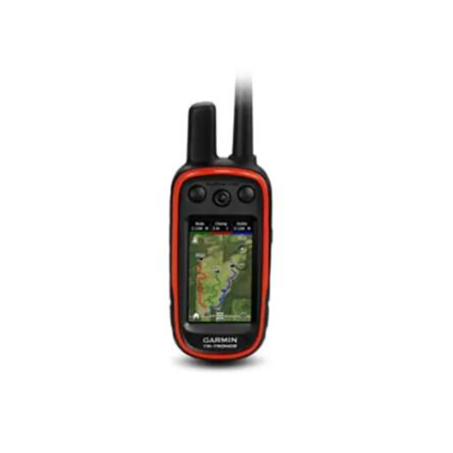
Multi-dog Tracking GPS and Remote Training Device in One
An invaluable tool in the field, the Alpha 100 helps you achieve optimum performance from your sporting dogs. It combines proven Garmin GPS dog tracking with Tri-Tronics® electronic dog training technology. This easy-to-use integrated handheld system allows you to track and train your dogs in the field at a range of up to 9 miles away, delivering their exact position as often as every 2.5 seconds.
With multiple Alpha 100 handhelds and compatible dog collars (sold separately), pinpoint up to 20 dogs or hunters’ exact positions on a large, glove-friendly touchscreen display even when they are out of sight. Because Alpha 100 comes preloaded with TOPO U.S. 100K maps, you’ll always know your surroundings.
Tracks up to 20 dogs or buddies from up to 9 miles away when paired with compatible Garmin dog collars (sold separately)
18 training levels of continuous and momentary stimulation
Tone and vibration alerts
Preloaded TOPO U.S. 100K maps
Measures dogs’ speeds and distances traveled
General |
|
| Dimension | 2.5 x 6.5 x 1.5” (6.4 x 16.5 x 3.8 cm) |
| Weight | 8.8 oz (250 g) with standard antenna and battery |
| Waterproof | IPX7 |
| Touchscreen | ● |
| Display Type | transflective, 65-K color TFT touchscreen |
| Display Size | 1.53"W x 2.55"H (3.8 x 6.3 cm); 3" diag (7.6 cm) |
| Display resolution | 240 x 400 pixels |
| Battery type | rechargeable lithium-ion (included) |
| Battery life | up to 20 hours (Alpha 100) |
| Memory/History | 4.0 GB |
Maps & Memory |
|
| Preloaded maps | yes (topographic) |
| Ability to add maps | ● |
| Basemap | ● |
| Automatic routing (turn by turn routing on roads) for outdoor activities | Yes (with optional mapping for detailed roads) |
| External memory storage | microSD™ card (not included) |
| Waypoints/favorites/locations | 4000 |
| Navigation Track Log | 10,000 points, 200 saved tracks |
| Navigation Routes | 200 |
Sensors |
|
| Barometric altimeter | ● |
| Compass | Yes (tilt-compensated 3-axis) |
| High-sensitivity receiver | ● |
Outdoor Recreation |
|
| Area calculation | ● |
| Fish forecast | ● |
| Sun and moon information | ● |
| Custom maps compatible | ● |
Customer Service QQ
Customer Hotline:
Technical Supports


 3003988120
 yiqi.com
 bio-equip.com
 b2bwork.baidu.com
 baidu.com